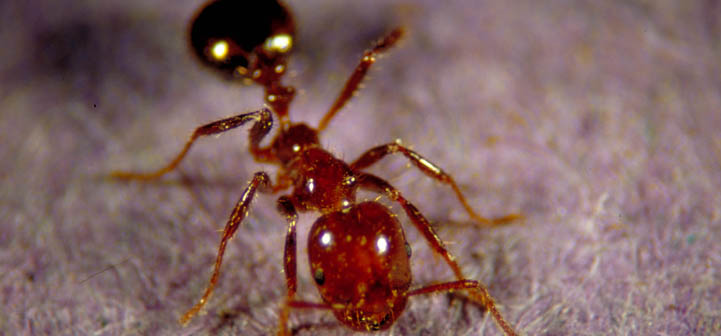
This map of imported fire ants and their natural enemies is a compilation of information from many sources. Sources include published data as well as information provided by fire ant experts.
Data for the maps are curated by Kathy Flanders, Department of Entomology and Plant Pathology, Auburn University on behalf of the Ant Pests eXtension Community of Practice. In collaboration with the Southern IPM Center, the Bugwood Center for Invasive Species and Ecosystem Health houses the data and maps that you see on this site. This is made possible through the Early Detection and Distribution Mapping System (EDDMapS). This effort also makes the data available for reuse in research and extension projects. For information on accessing data or using any of the maps, contact Rebekah Wallace.
If you have new reports of fire ants, please report them through the Southeast Early Detection Network website or apps for Android and IOS.
Source Citations for the Interactive Imported Fire Ant Map Layers
The Imported fire ant quarantine map, June 2016, published by the United States Department of Agriculture – Animal and Plant Health Inspection Service, Plant Protection and Quarantine – Invasive Species and Pest Management at was used to indicate U.S. counties under full or partial federal quarantine. The data was originally provided as an ArcGIS shape file courtesy of USDA APHIS and is updated as new counties are federally quarantined.
State Quarantine Layer
Sometimes states impose quarantines additional to the federal quarantines where they deem necessary:
- California Department of Food and Agriculture
- Tennessee Department of Agriculture Plant Industries Division
- North Carolina Department of Agriculture and Consumer Services Plant Industry Division
Have or have had populations of fire ants
Additional counties where red imported fire ants have been reported were retrieved from National Agriculture Pest Information System; Kelly Loftin Personal Communication; and Oklahoma State University; Joe Collins, Janet Lensing, and David Quimayousie, Personal Communication.
Imported Fire Ant Species Layer
Some states (Tennessee, Mississippi, Arkansas, Georgia, Alabama, North Carolina, and South Carolina) have red, black, and hybrid imported fire ants. The other infested states have just red imported fire ants. Species identification was determined using cuticular hydrocarbon analysis.
Distribution of black imported fire ant and hybrid (red x black) imported fire ant was obtained from:
- Tennessee: Vail and Parkman, 2008, University of Tennessee Extension Imported Fire Ants website, and Oliver et al. J. Entomol. Sci. 44(2): 149-157 (April 2009).
- Mississippi: Streett et al. Florida Entomologist, 89(1):91-92. 2006.
- Arkansas: Kelly Loftin, Personal Communication.
- Georgia: Gardener et al. J. Entomol. Sci. 43(1): 133-137 (January 2008).
- Alabama: Bertagnolli et al. Proceedings of the 2007 Annual Imported Fire Ant Conference April 23-25, 2007 Gainesville, Florida, USA (pg 112-115).
- Personal communication: Kelly Loftin and David Cross
Potential Range Expansion Layers
The potential range is based on modeling the cold hardiness of red imported fire ants. Two range expansion scenarios are presented, one based on natural rainfall, and one allowing for supplemental irrigation. The black imported fire ant is more cold hardy and in places already occurs outside the potential range. The potential range expansion of red imported fire ants was based on the following publications:
Korzukhin, M. D., S. D. Porter, L. C. Thompson, and S. Wiley. 2001. Modeling Temperature-Dependent Range Limits for the Fire Ant, Solenopsis invicta (Hymenoptera: Formicidae) in the United States. Environ. Entomol. 30(4):646-655.
Morrison, L. W.,, S. D. Porter, E. Daniels and M. D. Korzukhin. 2004. Potential Global Range Expansion of the Invasive Fire Ant, Solenopsis invicta. Biological Invasions 6:183-191, 2004
Natural Enemies of Fire Ants Layers
Pseudacteon flies, also called decapitating flies, are native to South America. Maps of the distribution of Pseudacteon litoralis, Pseudacteon obtusus, Pseudacteon curvatus, and Pseudacteon tricuspis species are included. Data for these maps are from the following sources:
Pseudacteon litoralis: Fudd Graham and Kelly Palmer, Personal Communication.
Pseudacteon obtusus: The University of Texas at Austin Fire Ant Project 2011, Plowes et al BioControl (2011) 56:295–304, and Sanford Porter Personal Communication.
Pseudacteon curvatus: The University of Texas at Austin Fire Ant Project 2011 , Meszaros and Johnson LSU AgCenter 2011, Kelly Loftin, Personal Communication, Farnham and Loftin 2011 http://www.bioone.org/doi/full/10.1653/024.094.0103, Callcott et al 2011 http://insectscience.org/11.19, Fudd Graham, personal communication, Anne-Marie Callcott, personal communication, Sanford Porter Personal Communication.
Pseudacteon tricuspis: The University of Texas at Austin Fire Ant Project 2011 , Callcott et al 2011 http://insectscience.org/11.19, Meszaros and Johnson LSU AgCenter 2011 Personal Communication, Farnham and Loftin 2011 http://www.bioone.org/doi/full/10.1653/024.094.0103, Fudd Graham, personal communication, Anne-Marie Callcott, personal communication, Sanford Porter Personal Communication.
Kneallhazia pathogen
Data on Kneallhazia solenopsae, a microsporidian pathogen, is provided courtesy of Dr. David Oi, USDA CMAVE, Gainesville, Florida.
Map Management
Map layers are curated by Kathy Flanders, Department of Entomology and Plant Pathology, Auburn University on behalf of the Ant Pests eXtension Community of practice.
If you find errors in the map, please contact Kathy Flanders.
For information on accessing data or using any of the maps, contact Rebekah Wallace.
Acknowledgements
Thanks to the Southern IPM Center, the Bugwood Center for Invasive Species and Ecosystem Health and the Early Detection and Distribution Mapping System (EDDMapS).
Special thanks to Bart Drees, Jason Oliver, Kelly Loftin, Anne-Marie Callcott, Sanford Porter and members of the Imported Fire Ant Community of Practice for valuable feedback and participation.
Please note: State and federal imported fire ant quarantines require action on the part of individuals shipping high-risk articles (e.g., turf grass, nursery stock, hay bales, pine straw, bee hives) according to inspection and treatment guidelines published by USDA-APHIS and individual states. Fire ants may have been reported in counties outside the quarantined area. These reports may represent historical information as well as areas of current infestations based on citations and personal communications listed. Contact your state departments of agriculture and/or USDA-APHIS to report suspected imported fire ant occurrences or with questions regarding current distributions and treatment regulations.
